K a m e n n ý M o s t (Stone Bridge)
50°14´26´´n. l. ; 14°11´34´´e. l.; 250 m
Kamenmost; a settlement from 11th century near a rear stone bridge over Knoviz brook. In 1088 the king Vratislav II donated this settlement to Vysehrad chapterhouse; in 1444 in possession of Bartosh Ptak who for some time held also Drinov; he was the mayor of Slany. In 16th century owned by Hrobcicky clan from Hrobcice; confiscated and sold to Adam from Valdstein.
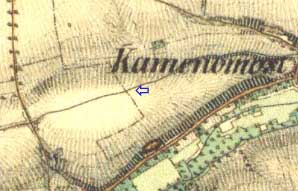
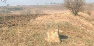
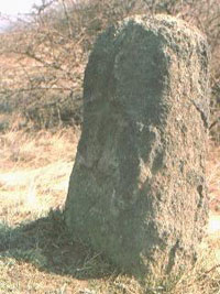
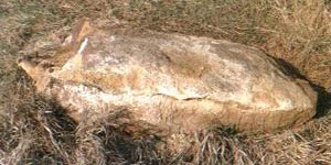
On the maps it is marked with the local name U kamene (At the Stone). It can be found at the end of an old drive 250° to the west about 1 km from the village, at the place providing a wide spreading all-round view, at ground elevation 250 m. Originally it used to stand right at this ground elevation, but stood in the way of levelling so it was relocated. Flattened prism made of grit (coarse-grained sandstone) or even a cobblestone of about 0,8 tons in mass, 77 cm high above the ground, its wider side 67 cm long at the base and 50 cm at the highest, width at the bottom equal to 30cm and 20 cm at the highest.
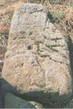
It has an extremely weathered surface. On its wider northwest side (Az 306°direction) one can clearly see a lithogravure of a Latin cross on a pedestal, made in negative relief. The scratch (groove) is 4 cm wide and 2 cm deep. Pedestal of the cross has the following dimensions - 28 cm at the bottom, 23 cm at the top, 12 cm high. Horizontal arm is 21 cm overhead the pedestal, 23 cm wide. Vertical arm continues 30 cm up to the stone top where a hole is quite apparent (maybe due to the cross that had been fitted there).
It is located near a prehistoric site with findings of voluted ceramics, stone and bone implements. When adapting an entry to the field back in 1896 two humam skeletons were discovered just by chance with one of the sketetons allegedly reaching as far as below the Stone itself. But before V. Schmidt could have had carried out his research the local civilians - allegedly due to their superstition - had demolished the uncovered grave and littered the bone fragments all across the field where it lay scattered all around. A tiny piece of iron should have had been found allegedly near the skeletons which might enable us to date the Stone location within a historic time. Unfortunately this important finding was not preserved as well. Some research workers assume this Stone is an indication of a grave of some outlaws (disinherited sons, outcasts) that used to be buried outside the parish, and thus representing a real cross stone.
What kind of superstition is meant here? Fear of the dead? Inhabitants would then have to be aware of who has been buried here and therefore the grave would not be too old and consequently neither the stone would be to old. However per local tradition the stone used to stand here since time immemorial. If some fear of these dead has been the case, then why they had been first buried in a normal way. Is it possible at all that village inhabitants at the end of 19th century would act in this way towards human remains no matter they knew whose they are or not. The Stone used to stand on the highest point so most likely the outcasts would have had never been buried over here. Access to the field from the hollow way path (drive) is outside the ground elevation, so where this grave was located was it the only one, or something else is situated there? According to my opinion it is rather a borderline stone in between the plots of two (three) clans, or a milestone ...
Within the vicinity we came across other interesting stones, that is right within the hollow way (cutting), but if brought here from the field or intentionally located like that, we do not konw. They stand along the entire length of the hollow way, this one is the biggest one of them. It lies within the field in northwest direction at the distance of about 300 m.


