ÿþ<!DOCTYPE HTML PUBLIC "-//W3C//DTD HTML 4.01 Transitional//EN"> <html> <head> <title>Kersko</title> <meta http-equiv="Content-Type" content="text/html; charset=iso-8859-2"> <meta name="AUTHOR" content="Pritulová Miroslava"> <meta name="keywords" content="Kersko, menhir"> <link rel="stylesheet" type="text/css" href="../screen.css" media="screen"> <link rel="stylesheet" type="text/css" href="../print.css" media="print"> </head> <body> <div class="list"> <h1>K e r s k o - H r a d i a t k o&nbsp;&nbsp;&nbsp;n e a r&nbsp;&nbsp;&nbsp;S e d l  a n y</h1> <h2>50°09´56´´n. l. ; 14°55´28´´e. l.; 180 m. u. s. </h2> <div class="bar"></div> <p><i>The Church of Corpus Christi used to be found near the main road. Its plan can still be clearly seen having different flora, and was oriented in north-south direction. They buried here from everlasting. On tourist maps it is marked U kamene (Near Stone), already on the map from year 1842.</b></i></p> <img src="pic/big/kerskoold.jpg" style="float:left;width:300px;height:100px;margin:5px;" alt="Kersko; http://www.geolab.cz"> <img src="pic/small/mkersko.jpg" style="float:left;width:300px;height:100px;margin:5px;" alt="View of river Labe"> <img src="pic/big/kersko2.jpg" style="float:right;width:250px;height:188px;margin:5px;" alt="Kersko-Hradistko"> <p><br> 
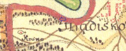
It might be an old path to Nymburk led through this area and the given stone served as milestone. 
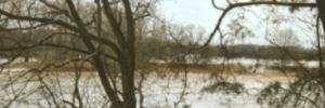
The stone is situated about 8 km southeast of Lysa nad Labem (Lysa on Elbe) , on this river s left shore, less than one kilometer from Hradistko village. It is possible the level of Elbe river reached within the Stone s nearest vicinity thus being of significance for the boatmen, surely it must have had been clearly visible from the river. </p> <img src="pic/big/kersko1.jpg" style="float:left;width:200px;height:265px;margin:5px;" alt="Kersko-Hradistko"> <p>
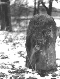
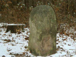
Bush-hammered (outlined, hewn) sandstone of rectangular plan ca 50 x 30 cm, is 76 cm high above the ground, not known how deep it has been set in the ground.<br> Its mass is estimated to equal to 200 kg.</p> <img src="pic/small/nkersko.gif" style="width:180px;height:165px;margin:15px;" alt="Kersko-Hradistko"> <p>Zde uvedená informace o zni ení lokality v roce 2005 byla mylná. Jak vyplývá z dopisu pana Svatopluka `ebka: <i>"Musím Vám s radostí sdlit, ~e kerský menhir je v poYádku a je, zejména v sezon, asto navatvován turisty jednotlivými i celými skupinami. Menhir, jak je na Vaaich fotkách, je pouze "nadzemní " ást. PYed nkolika léty jeden z turisto se sna~il odkopat zeminu okolo kamene do hloubky asi 1 metru a zjistil, ~e tato horní ást kamene "vyrostá" ze základního hranolu velikosti asi 1 x 1 metr neznáme hloubky . SamozYejm jsme s celou rodinou u toho byli a vidli to. Turista si to ofotografoval, kámen zase pe liv zasypal a odeael, tak~e fotku bohu~el nemám, proto~e jsem ten den neml s sebou foeák, ale je to pravda...</i> </p> <div class="navig"> <a href="kamennymost_en.html"><img class="sipka" alt="Kamenný Most" src="../images/sipkal.gif"></a> <a href="index_en.html"><img class="spiralka" alt="Back" src="../images/spiralka.gif"></a> <a href="klobuky_en.html"><img class="sipka" alt="Klobuky in Bohemia" src="../images/sipkar.gif"></a></div> </div><div class="copy"> Text and fhotos: &copy;Pritulová <br> Cut historical maps: &copy; 1st (2nd ) Military Survey, Section No. xy, Austrian State Archive/Military Archive, Vienna<br> &copy;Geoinformatics Laboratory, University of J.E.Purkyne; http://www.geolab.cz<br> &copy;Ministry of Environment of Czech Republic; http://www.env.cz </div></body></html>