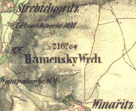
V i n a r i c e (Co: K l a d n o)
50°11´? N; 14°05´? E; 412 m ASL
The vinters´settlement reminded in year 1227 already; findings from within the vicinity dating back to 5th millenium and later /vinarice type, Lusatia and German cultures A.D.; fortress (stronghold, castle) or thane seat; it belonged to Saint Gotthard Monastery; later to Martinic from Smecno.
It is assumed the menhir used to stand
on Vinarice Hill elevation of 412 m
or on the adjacent hill top 408 m, from where it was toppled.
It could have had however been situated in the col as well.
Říp mountain is clearly visible from this point.
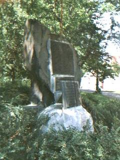
Quartz rock was used to build World War I
memorial situated just opposite the Municipality.


