T u c h l o v i c e (Co: K l a d n o)
50°08´16,55´´N; 13°59´24,37´´E; 432 m ASL
One gets to the territory of this village when walking along Kačák (Kachak) stream and Tuchlovice creek. There are unique archeological findings; tools from Paleolith belonging to era of Mousterien culture (110000 years ago) right at the spot of the building with indication number 227; Neolithic Age Volutic culture and Poke-Out culture, these tools were found behind the farms with indication numbers 4 and 12, and at the position situated on so called Na Dolíkách (On the Pits, Ridges); Eneolith with the culture of so called Funnel Cups and the Channeled Culture (Grooved, Fluted, Corrugated Culture) found behind a farm with indication number 5 the findings have been verified by Mr. Buchvaldek, Dr.; the Bronze Age represented by Unětická culture and cairn culture again behind the farm called U Nejtku, indication number 12 a mould for bronze casting was found there (today placed in the National Museum in Prague verified by Mr. V. Moucha, Dr.)
Extensive settlement Czech-Paletinate Cairn Culture found during incidental excavations (indication number 227 and reaching as far as the new school is, until the farm of Mr. V. Kohout); Knoviz Culture from the restaurant U Marešů along both of the sides of Karlsbad Road up to the Čeledovi family building indication No. 459 the age estimate is 3000 years old. The second settlement is near the delivery track leading to Důl Tuchlovice (Tuchlovice Mine). The third settlement location used to be situated within Důl Tuchlovice and eastward thereof. Iron Age tiny remains of vessels coming from Bylan Culture (behind farm with indication No. 12). Laten Culture large settlement near the aber of Tuchlovice creek and Bambaska downstream the former Salačova brick kiln (research carried out by Mr. Axamit, Dr. findings placed in the National Museum in Prague). Mrs. MotykovaSneidrova, Dr. has found here a number of ruins concerning a couple of buildings. A second settlement was found within the area of Choboty in the direction toward the house of Srbovi family (age of about 2500 years). The era of Roman Empire within the location of former mill indication No. 16 the swamp managed to hide wooden structures overhere, parts of a ladder, parts of dishes, bowls, handles, everything made of wood. The terrain used to lie about 2 m below the existing level, and was covered by mud fillings (research made by Mrs. Motykova Sneidrova, Dr.). Also a pyrogenic grave found within the garden indication No. 36 comes from the same period. A rich grave from the era of Celakovice type of merovigian culture dating back to 5th century A.D. was found when building the house indication No. 87. The Slav skeleton grave along with bowl (little vessel) and iron knife from (9th century) was discovered here concerning Elder Fortification Era. Skeleton graves from 10th and 11th centuries complete with bronze ear-drops were discovered within Nova Quarter and Railway Station (Nádražní) Quarter. Many of the researches were carried out to the credit of local enthusiastic archaelogist Mr. Vaclav Trnka who used to collaborate with Archaeological Institute of Czech Academy of Science (Archeologický ústav ČSAV).
Memorial Stones.
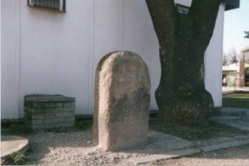
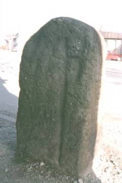
There is a memorial stone standing behind a former bus waiting room. It is the state-protected monument. On one side of sandstone quader with rounded top there is - not quite well perceptible - carved cross with the era of 1813, and on the other side there is a sword. In the village a legend passes from generation to generation telling that there used to be marshes and swamps just within the area the stone is standing today, and during Napoleon wars dragoons sank (fell through) here complete with their horses. There have been swamps within the village green, and moisture occurs there constantly regardless of all the asphalt work done. However the dragoons would have had to be of high ranks to deserve such a memorial to be built for their commemoration. Another version speaks about a shifted boundary mark of former Smečenské manor (dominion).
Still another version of the legend, by the way the most likely one, speaks about the stone being an alert one warning about hazards of marchy ground, and the sword then warns against stealing or breaking the danger sign.
A similar stone used to be positioned behind the castle wall near former old school within the park area.. Today it is not there anymore, witnesses recall it was standing there still in the 20th to 30th of the last century. It must have had either sunk down through the muddy subsoil or somebody took it home as building material. It simply disappeared.
The third stone disappeared as well. It used to stand alongside a field path downstream Důl Tuchlovice (Tuchlovice Mine) in the direction to Kolomazna cesta Axle Grease (Dope) Path near the entrance to the gorges called Karlici and Peklici. The era 1848 and KH and VH initials were engraved into this third stone. These represent the names of Hora brothers - students that according to the legend were murderd here by militia that chased them down during 1848 revolution, and were maybe even buried here. Fugitive Hora brothers were fleeing from revolutionary Prague at that time. Even this stone had disappeared some time before Nazi occupation, probably serving somebody as a rather convenient building material.
All the three stones had been artificially built with certain intentions in mind not fully explained to this date.
In none of the cases menhir is invoved.
Many thanks for this entry to Mrs. Sokolova from Tuchlovice

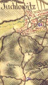
The village had been set up on the ancient road to Cheb; roman walls of Saint Havel Church dating back to 12th century; it reminds of the year 1283; within the village green there is a stone resembling those boundary marks in Běleč, Bratronice, Červený Újezd, Nové Strašecí. It either marks a territory (section) line (Křivoklat dominion, so called Kingdom) or a solid point of ancient path when there were numerous marshes all aroud Tuchlovice.
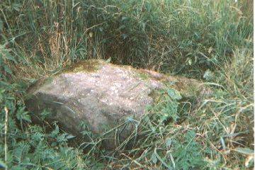
Brown sandstone grit has been found in 1991 within the trench near the path from Tuchlovice to Nosek coal mine, about 200 m away from mine area.
It was discovered by geologist Mr. V. Daněček who made a detail documentation on the finding.
The stone is 1,3 m long, 74 cm wide and 55 cm thick. It is most likely the original place it was lying on was the field nearby the path from where the stone was then removed to an unknown place by an unknown person.
The spot has not been identified on the map nor is there any indication of local name.


