B u d i h o s t i c e
50°17´??N; 14°15´??E; 230 m ASL
Budihostice lies on stream Bakovsky about 2 km norteastward from Velvary. Budihostice; in the year 1045 during Břetislav I. reign it belonged to Brevnov Monastery, in 1088 partially to Vysehrad Church. Budohostice supplied food to royal court of Přemysl Otakar I. Back in 13th century it represented yeomanly meeting; then from 14th century it served as stronghold castle from which an underground corridor led to the stronghold castle in Dolní Kamenice.
Budihostice were free village to the y. 1848, in central Bohemia of the only of end 18th Cent.
Local name Ke kamenu (Towards the Stone) about 1 km eastward from Miletice village; on the cadastral map from year 1840 there is another spot about one kilometer more to the south named similarly, i.e. K kamenu. It is contentious whether these are identifications of places for stone collections, or for occurrence of menhires. ???
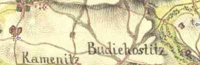
I. military mapping - Francis-Joseph II.
1764-1768 a 1780-1783 (rektifikace), 1:28 800
Occurrence of menhires is problematic.


